Top menu

  • Customer Service
  • Find a Rep
  • Canadian Customers
  • 800-542-2595
  • 877-542-2596 | M-F 9am-5pm EST
  • Log in
  • Create account
  • Checkout

Css captcha

Js and css

Header logo

Block as products carousel: 
Block as images slideshow: 

Header Info

Block as products carousel: 
Block as images slideshow: 
My List (0 items) $0.00

Sub menu for static pages

  • Home
  • Correlations
  • Interactive eBooks
  • eBooks
  • Reviews
  • Request a Catalog
  • Downloads

Sections menu

  • First
    Concepts
  • Early
    Readers
  • Leveled
    Readers
  • Fun Fact
    Files
  • Crash
    Course
  • Hot
    Topics
  • Subject
    Content Areas
    • Arts & Crafts
    • Biographies
    • Careers
    • Character Education
    • Graphic Fiction & Nonfiction
    • Cooking & Food
    • High Interest
    • Language Arts / Literature
    • Math
    • 100 Facts You Should Know
    • Science
    • Social Studies
    • Sports
    • Transitions to Literacy
  • Spanish/
    Bilingual
| Title Page

Mapping Asia

Mapping the World

Library Bound Book List: $25.27 / S&L: $18.95
Interactive eBook List: $33.25 / S&L: $24.95
eBook List: $25.27 / S&L: $18.95

Reading Level: 2-3

Interest Level: 2-5

Product type: Library Bound Book
ISBN: 978-1-4339-9099-1
Author: Barbara M. Linde
Copyright: 2014
Language: English
Pages: 24
Trim: 8.5" x 8.5"
Dewey: 915
ATOS: 4.2
ARPoints: 0.5
Subject: Social Studies
Binding: Library
BISAC: JNF038020, JNF058000
Cultural Background? • Glossary • Maps • Index • Social Studies Content • Age Appropriate and Achievable Content • Fact Boxes • Detailed Table of Contents • For Further Information Section
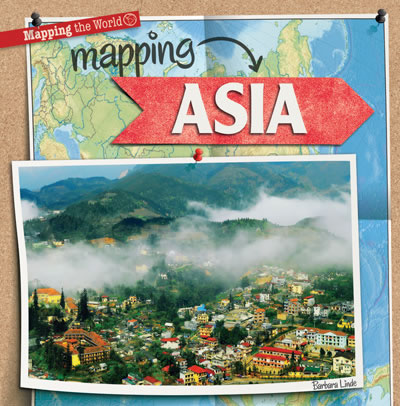
The largest continent in the world also has three-fifths of the world's population! Asia is made up of more than 50 countries and has huge mountain ranges, island nations, and a rich collection of varied cultures. Its large size and diverse geographic features make this continent a great place to start learning to read maps. Simple political, landform, and climate maps introduce readers to some of the most common types of maps, while colorful photographs show them the beauty of Asia beyond boundaries and longitude lines. Age-appropriate language engages readers in content consistent with the social studies curriculum as fact boxes add fun facts about mapping and the great Asian continent.
Accelerated Reader Level Points
2-3 4.2

Footer left part


29 East 21st Street,
New York, NY 10010

Tel: 800-542-2595
Fax: 877-542-2596

Hours:
Monday to Friday 9am – 5pm
Block as products carousel: 
Block as images slideshow: 
  • Company info
    • About us
    • Contact Us
    • FAQs
    • Canadian Customers
    • Find a Rep
    • Careers
    • Privacy Policy
  • Resources
    • Correlations
    • RL Correlations
    • Interactive eBooks
    • Transitions to Literacy
    • eBooks
    • Reviews
    • Request a Catalog
    • Downloads

Gareth Twitter

Tweets by @GS_Publishing

accesiBe Widget

Copyright

Copyright ©2025 Gareth Stevens, Inc. or its affiliates. All rights reserved.
Follow Us On:
Block as products carousel: 
Block as images slideshow: